The Old School Way
Estimating the angle
The New Method
The Cheater Way
An Alternate Method
Introduction
Angle shooting, or "slope dope" as many people know it, is an interesting phenomenon that can bite you at the worst time, but yet is very scientific in its solution. If you know the angle, the range, and your exact ballistics for the weather conditions, then it is fairly easy to compute a fairly accurateamount amount of adjustments to dial in and hit your target. The problem is the math, and knowing that exact angle you are shooting at. To define it in its simplest form, slope dope is simply the amount up the bullet will strike because of an angle you are shooting either up or down. One key element here is that your bullet will ALWAYS strike high, whether you are shooting up hill, or down hill. That is the first rule of slope dope. In fact, the bullet will strike the SAME distance high whether you are shooting 20 degrees uphill or 20 degrees downhill.
The Old School Way
Now, let us take a look at the old school way of what is happening here. Generally, when you estimate range to a target, MOST of the time you will use a Mil-dot reticule, your naked eyes, or even a laser range finder. All of these methods measure the distance directly to your target in a straight line. The trick is that gravity only acts on the bullet while it is traveling along the horizontal axis, which will be shorter than the straight line distance from you to the target when shooting at an angle. How about a picture?
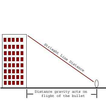
Now, some of you that are not too far removed from school may notice that this all looks a bit like Geometry class (or was it Trig?). As we can tell, the important distance to know is the distance along the ground, or the x-axis, because this is the distance at which gravity acts on the flight of the path, and this distance is the one that all of our ballistic charts will be accurate for. Now, if you remember back to that geometry class, you will remember that if we have the angle and the hypotenuse, then we can figure out the x and y distances by using some trig functions known as sine and cosine.
Well, it so happens that the formula we are looking for is:
Straight line distance (hypotenuse) * Cosine Angle = distance effected.
So, let us look at that picture again with some numbers put in for an example.
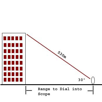
So, filling in the variables to figure out the range to dial into the scope we get the following: 530 * Cosine(30) = X distance to target.
Doing the math we get 459 meters as the distance we should dial in for our range on the scope to hit dead on. Now, I know that everyone can compute the cosines of any degree in their head, right? Well, neither can I, so here is a precompiled table for you.
| angle | 5° | 10° | 15° | 20° | 25° | 30° | 35° | 40° | 45° | 50° | 55° | 60° | 65° | 70° | 75° | 80° | 85° |
| Cosine | .99 | .98 | .96 | .94 | .91 | .87 | .82 | .77 | .71 | .64 | .57 | .50 | .42 | .34 | .26 | .17 | .08 |
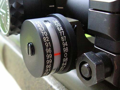
Now, you can use the above data (or a scientific calculator) to build a precompiled table with degree angle across the top, and range in 100m increments down the side and fill in all the data so you have a quick reference look up chart... in fact, most logbooks that are on the market have this data compiled for you.
Estimating the angle
Of course, this is all fine and dandy on paper, but in the field, things can get tricky, especially trying to compute the angle to the target. Of course, you can always guess, which will get you closer than making no adjustment at all. Then there is the method of having the spotter put a protractor along the barrel of the rifle while the shooter aims, with a dangling piece of string with a weight on it attached to the middle of the protractor, and then read the angle that the string passes. Or you can actually do the math if you know how high or low the target is from you, or you can buy one of the "cosine" indicators that attaches to your scope base. The most common one out there, and the one sold by Badger Ordnance, is the one made by Sniper Tools Design Company. Here is a picture of their unit:
Notice that it does not tell you the angle, but tells you the cosine of the angle (hence the name of the item being the cosine tool). These are the same numbers that correspond to the chart I provided above of cosine values. Do these tools work? Yep, they do. They are also somewhat bulky and can get in the way, but are probably the best solution out there for determining slope dope. Simply estimate the straight line range using your eye, mil-dots, LRF and then multiply it by the number indicated on the cosine tool (with a decimal at the front, don't forget), dial in that dope (and any other adjustments) and engage.
The New Method
Now, the above mentioned way has been taught for many years and generally gets you pretty close. But it was determined that it is not totally accurate, and some research was done. Now let us just get one thing clear right now, there is no totally exact science here, and NOTHING can replace data that you gather yourself for your particular rifle. That is why log books are so important.
The idea with the new method is that you do not want to be applying the cosine modifier to the range, you want to be applying it to the total drop of your particular load. So, instead of taking the .87 for the cosine in the above example and multiplying it by the range, you want to multiply it by the TOTAL drop of your bullet at the estimated range (530m in the above example). So, at 530m, the M118 has a total drop (from the muzzle) of about 116" in normal conditions. So, multiply that by the cosine (.87) and you get 101", or a change of about 15" that you will need to aim low on the target. This is the equivalent of right about 500m or horizontal range, which is significantly different than the 459m we calculated using the old school method above (its rought about a 20" difference on target... that is a LOT!).
With the new method, you need to insure that you are applying that value to the total drop, and not the drop from 100m or a different zero, etc. The best thing to probably do is make up a chart for your log book for your particular load indicating the amount of adjustment you need to make at 100m increments in 5 or even 10 degree increments. The chart the US Army uses is actually in MOA adjustments, making it even a bit easier. This new method is the current taught method in most sniper schools and is considered to be the more accurate method to use.
The Cheater Way
Okay, obviously, the above methods are somewhat slow, unless using a chart, and less than precise, even using the cosine tool mounted to the rifle. So, leave it to our friends in the technology sector to come up with the ultimate cheater method of estimating slope dope, and it is probably even the most accurate. Several years ago, a start up laser range finding company contacted me asking about the desirability of having a LRF that could compute the angle to the target using an inclinometer and then give you the horizontal range to the target. My answer was "PERFECT!". They went on to develop the technology and sold it to one of the optics companies, I'm not sure who. But it seems the first to try it commercially was Pentax, but it never seemed to really take off. Now there are a few that do it, but I would have to say that Leupold has probably taken the concept the furthest with their recently released RX series LRFs, specifically the RX-3 and RX-4. It appears (we will be reviewing the RX-4 when it comes out) that it actually uses some of the "new" method of computations to give the ballistically modified data from the new method.
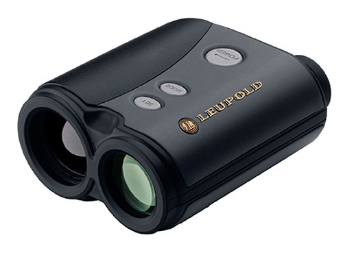
Leupolds new RX-4 angle compensating LRF
This is by far the best way to estimate both the range, and the angle compensated range. You know, it is like they say... "If you are not cheating, you are not trying hard enough".
An Alternate Method
There is one other method that I have used and I thought I would mention here. That is the map/gps method. The concept behind this is actually the same as the old school way, you want to get the horizontal or X distance the bullet is going to travel. It so happens, that by using a map to estimate your ranges or even better, by using a GPS to tag points and then get the distance to them, it only gives you the X distance. There is no computation or math that you have to do. If you are operating in an AO and have the ability to go and tag points on your GPS in your AO, do it. Then when you are over looking you can use the GPS to report to you the distance from your current location to the tag points and then use that data on your range cards and elevation settings on your rifle. Obviously, you will suffer from the same inaccuracies as the old school method, but I have used this method a number of times at degrees of up to about 25° and it was fairly accurate. But the steeper the angle and longer the range, the more inaccurate the old school method, and this one, is.
That should about cover it for this topic, now go forth and engage sloped targets!